Usando il “Visualizza gli input del vento di progettazione per tutte le direzioni” nel generatore di carico
L'analisi del sito è fondamentale nei calcoli del carico del vento. Conducendo questa analisi, possiamo determinare la peggiore direzione della sorgente del vento per generare la massima velocità e pressione del vento di progetto.
Nel generatore di carico SkyCiv, questo può essere fatto facendo clic sul pulsante "Visualizza input del vento del progetto per tutte le direzioni".. Tuttavia, questo è disponibile solo per ASCE 7, NSCP 2015, e AS / NZS 1170 per adesso. Presto, aggiungeremo gli altri codici di riferimento per facilitare il processo di progettazione.
Prova il nostro Generatore di carico SkyCiv!
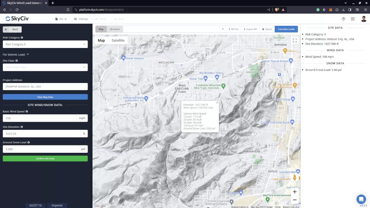
Dati del sito per il calcolo del carico del vento.
Facendo clic sul pulsante "Visualizza input del vento di progettazione per tutte le direzioni" sopra l'immagine della mappa, genererà i settori del terreno per ciascuna direzione. Genererà i parametri per ciascuna direzione e calcolerà le pressioni di velocità corrispondenti. Si noti che il raggio dei settori è uguale a 2 miglia per unità imperiali e 2 chilometri per unità metriche.
discuteremo gli effetti della topografia sul carico del vento sulle strutture calcolando il fattore topografico Kzt utilizzando ASCE 7 e NSCP 2015, la categoria di esposizione predefinita è D. Ciò influenzerà il valore del coefficiente di esposizione alla pressione di velocità \({K}_{z} \) poiché ciò dipende dalla categoria di esposizione della direzione controvento. La \({K}_{z} \) il valore sarà calcolato a 15 ft per unità imperiali e 4,5 m per unità metriche. Questo serve solo per confrontare le differenze di pressione cinetica calcolate per ciascuna direzione. Questo fattore verrà poi ricalcolato all'altezza media del tetto, \( h \), per la pressione del vento di progetto. Inoltre, il fattore topografico, \({K}_{zt} \), è calcolato a \( z = 0 M) poiché questo è il luogo in cui si può considerare il massimo effetto della topografia.
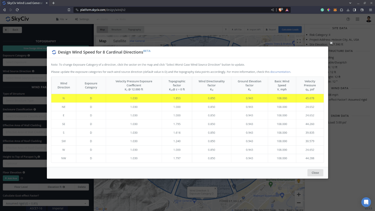
Valori iniziali per i dati sulla direzione della sorgente del vento nel caso peggiore.
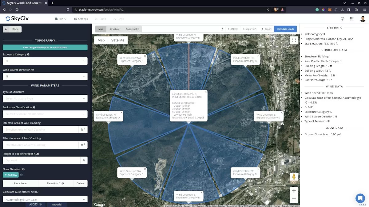
I settori modificabili del terreno/categoria di esposizione generati nella mappa.
Per AS/NZS 1170, la categoria del terreno predefinita è 1. Ciò influenzerà il valore del moltiplicatore terreno/altezza, \({M}_{z} \), poiché ciò dipende dalla categoria del terreno della direzione controvento. Questo \({M}_{z} \) il fattore è calcolato a 3 m di altezza per il confronto con tutte le altre direzioni. Questo fattore verrà poi ricalcolato all'altezza media del tetto, \( h \), per la pressione del vento di progetto. Inoltre, ciascuna direzione ha un moltiplicatore di direzione corrispondente, \({M}_{d} \), che ha sicuramente un impatto sulla velocità del vento di progetto. Inoltre, il moltiplicatore topografico, \({M}_{t} \) è calcolato a \(z = 0 \) poiché questo è il luogo in cui si può considerare l'effetto massimo.
Per aggiornare ciascuna categoria di esposizione o terreno, ti basterà cliccare sui settori all'interno della Google Map. Cambierà colore per indicare che la Categoria Esposizione/Terreno è aggiornata e mostrerà anche le informazioni sulla categoria esposizione o terreno selezionata. Dopo questo processo, è sufficiente fare nuovamente clic sul pulsante "Seleziona la direzione peggiore della sorgente vento" per aggiornare i valori nella tabella.
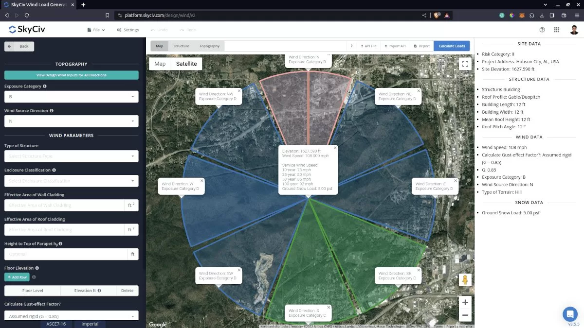
La categoria del terreno aggiornata per ciascuna direzione.
È sufficiente fare nuovamente clic sul pulsante "Seleziona la direzione peggiore della sorgente vento" per verificare le modifiche. Il valore massimo della pressione velocistica nella tabella verrà evidenziato e potrà essere cliccato per caricare automaticamente la direzione e la corrispondente categoria esposizioni/terreno nella scheda dati del sito.
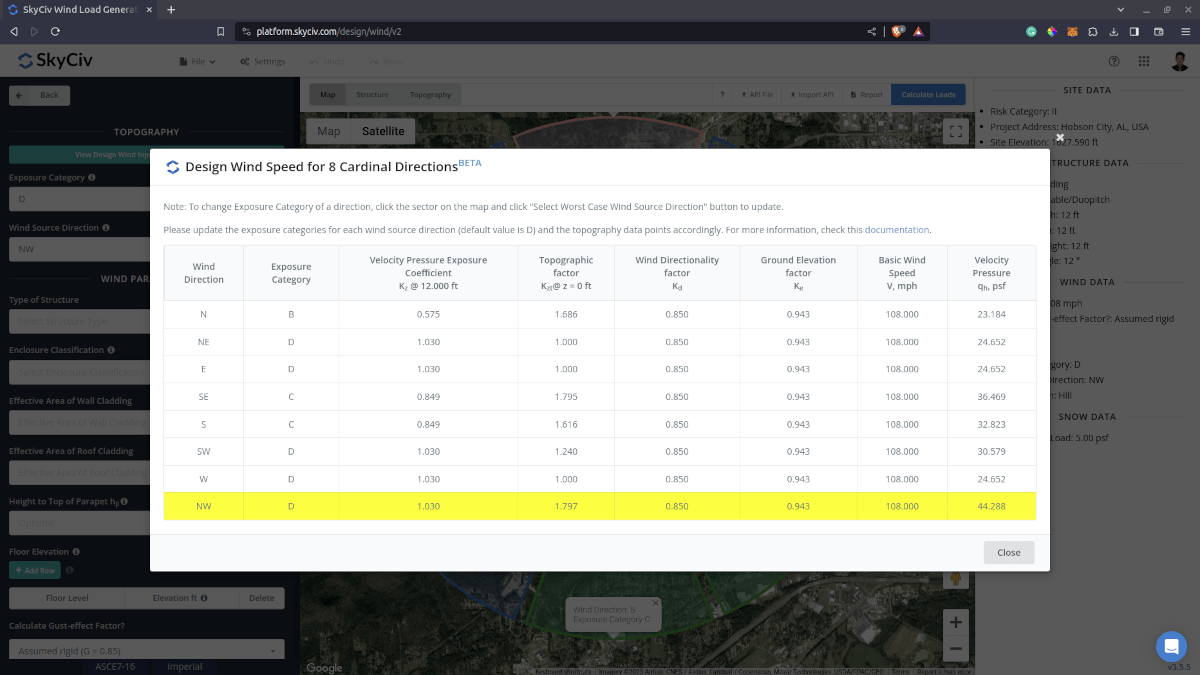
I parametri aggiornati per determinare la direzione della sorgente del vento nel caso peggiore.
Inoltre, è possibile ricontrollare e modificare il fattore/moltiplicatore topografico calcolato sul grafico dell'altitudine del suolo per direzione. Questo fattore verrà quindi salvato e utilizzato nel ricalcolo dei dati della tabella per determinare la direzione della sorgente del vento nel caso peggiore.
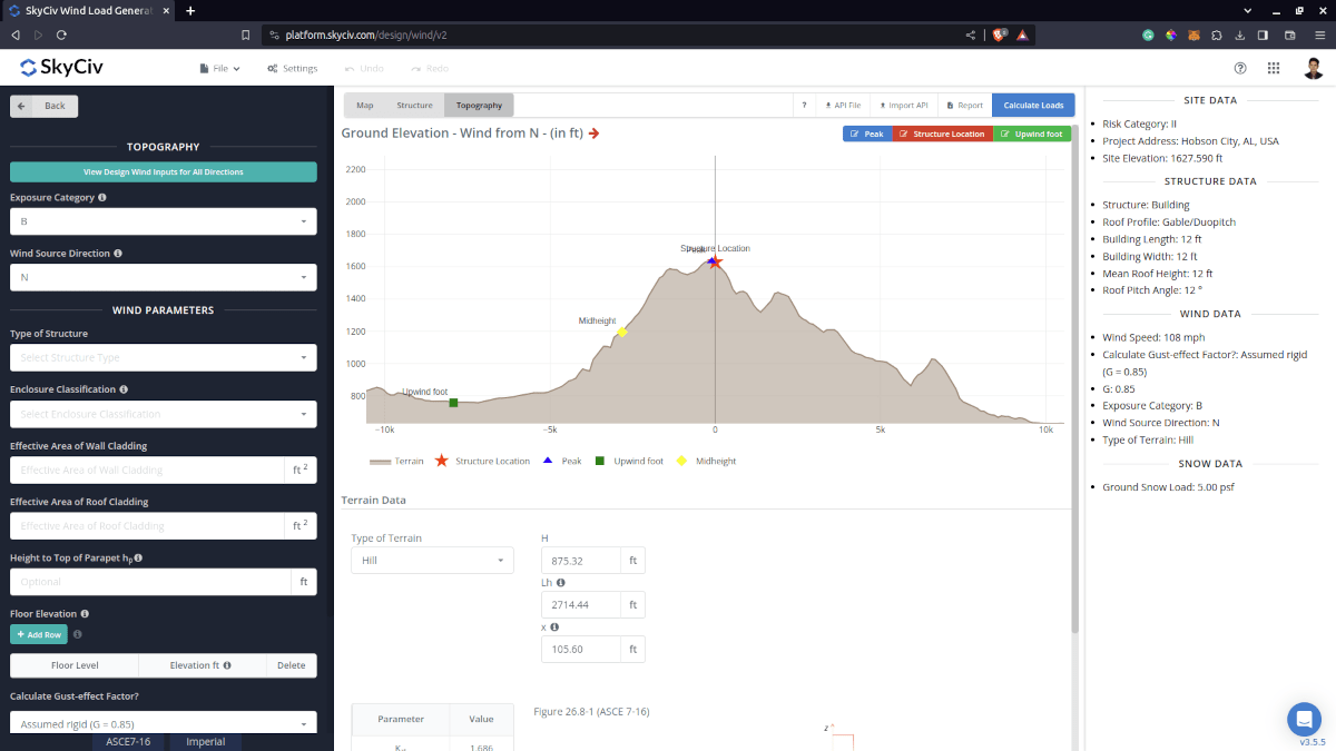
Il grafico dell'elevazione in cui è possibile modificare il fattore/moltiplicatore topografico per la direzione della sorgente del vento nell'analisi del sito.
Dopo aver modificato i dati di elevazione per direzione del vento, devi solo fare nuovamente clic sul pulsante "Visualizza input del vento di progettazione per tutte le direzioni" per mostrare i cambiamenti nella velocità/pressione del vento.
La pressione della velocità aggiornata dopo aver modificato il fattore topografico nel grafico Elevazione.
Tutto questo processo con pochi clic! Approfitta di questa funzionalità di la registrazione di un account professionale o acquistando il modulo generatore di carico autonomo!
Per risorse aggiuntive, puoi usare questi link:
- Introduzione a SkyCiv Load Generator
- Effetti della topografia sul carico del vento
- AS / NZS 1170.2 Esempio di calcolo del carico del vento
- ASCE 7-10 Esempio di calcolo del carico del vento
- ASCE 7-10 Esempio di calcolo del carico del vento
- NEL 1991-1-4 Esempio di calcolo del carico del vento
- ASCE 7-16 Esempio di calcolo del carico del vento per un edificio a forma di L.
- È 875-3 Esempio di calcolo del carico del vento
- Carichi di vento e neve per pannelli solari terrestri – ASCE 7-16
- Calcolo del carico del vento per la segnaletica – IT 1991