在这篇文章中, 我们将引导您了解如何确定场地位置上风侧的地形或暴露类别, 这对于计算风荷载至关重要. 我们将介绍 ASCE 中概述的具体程序 7, NBCC 2015, 和AS / NZS 1170.2 用于确定地形类别并讨论这些类别如何应用于 SkyCiv 负载生成器中可用的每个参考代码.
美国土木工程师学会 7-16/美国土木工程师学会 7-22
我们将通过计算地形因子来讨论地形对结构风荷载的影响 7, 确定场地位置逆风暴露的暴露类别的程序将在第 1 节中讨论 26.7, 取决于地形. 在这篇文章中, 以简化参考, 我们将使用 ASCE 7-16. 对于每个风源方向, 应从延伸 ±45° 的两个逆风区域进行分析.
数字 1. 每个风源方向的地形扇区.
对于每个部门, 表面粗糙度类别应根据以下定义进行检查 26.7.2 ASCE的 7-16:
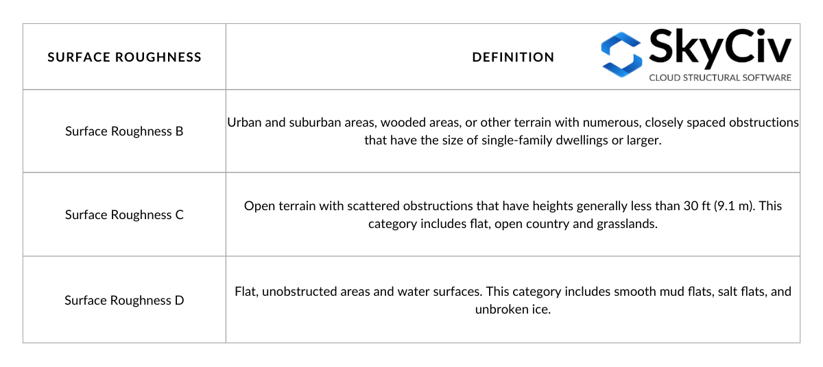
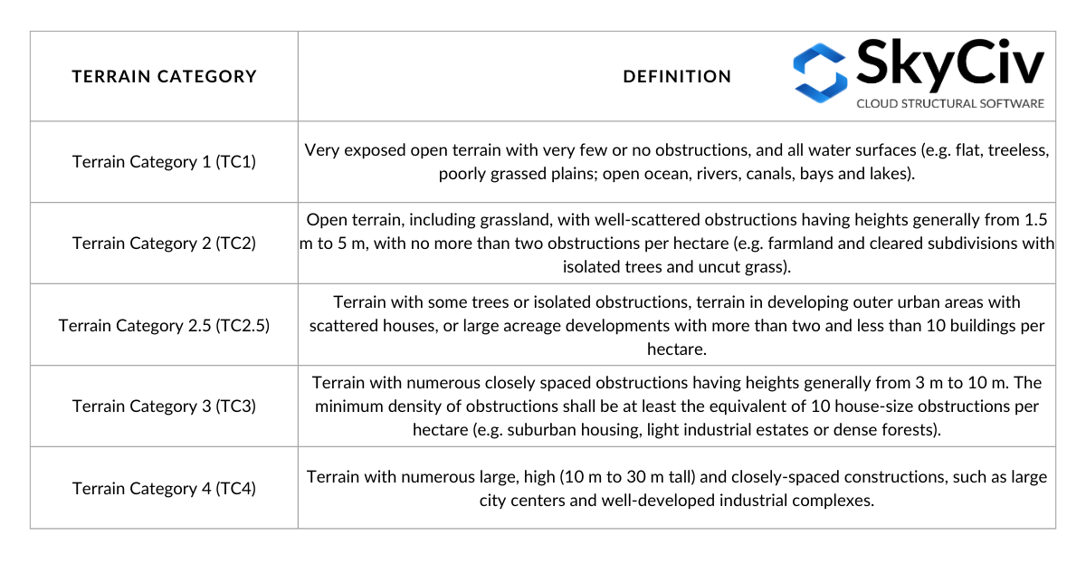
桌子 1. 基于截面的表面粗糙度定义 26.7.2 ASCE的 7-16.
从表面粗糙度的定义来看, 我们可以确定以逆风区为界的地形的暴露类别. 每个暴露类别的定义在第 1 节中说明。 26.7.3 ASCE的 7-16 如下:
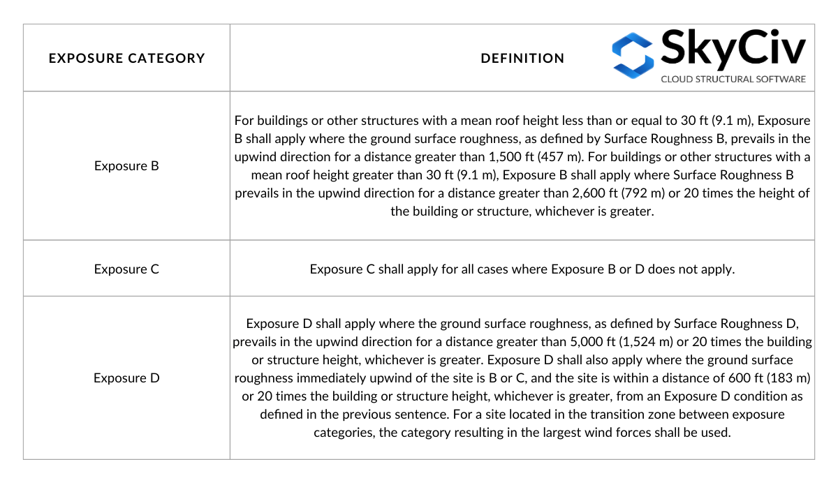
桌子 2. 基于部分的暴露类别定义 26.7.3 ASCE的 7-16.
桌子 2 可以根据图C26.7-2通过下图可视化:
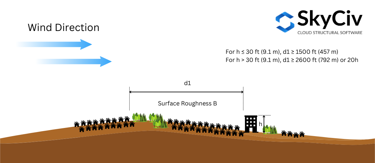
数字 2. 暴露 B 所需的逆风表面粗糙度条件.
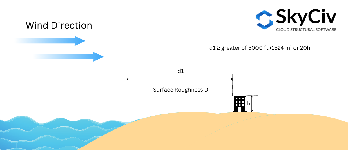
数字 3. 暴露 D 所需的逆风表面粗糙度条件 – 案子 1.
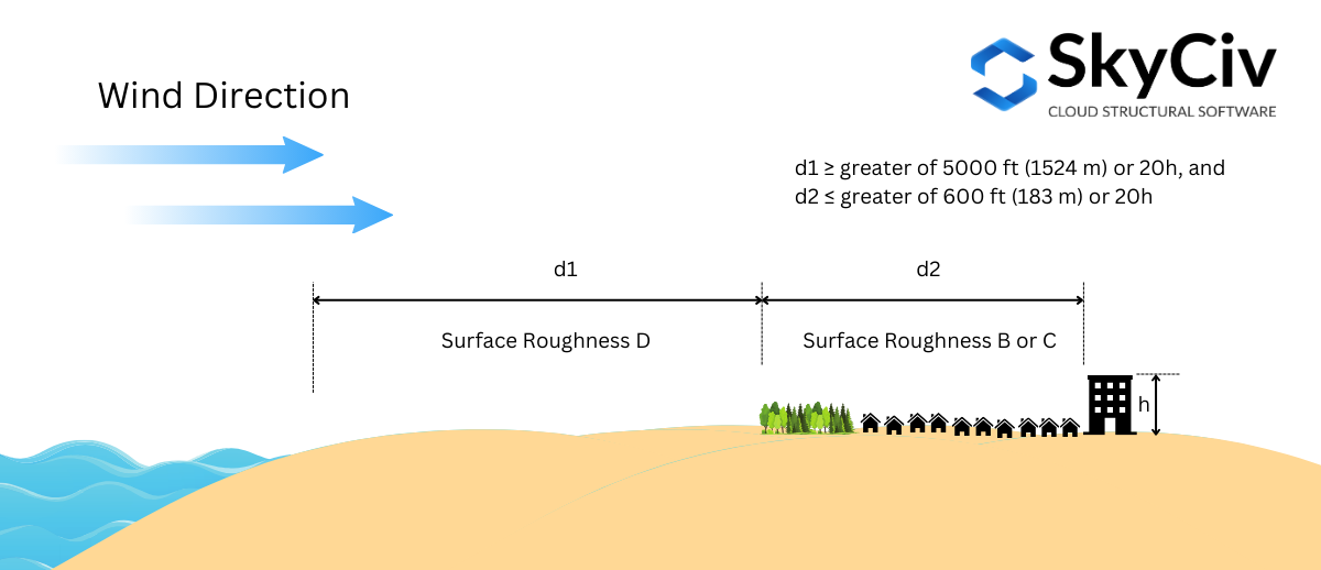
数字 4. 暴露 D 所需的逆风表面粗糙度条件 – 案子 2.
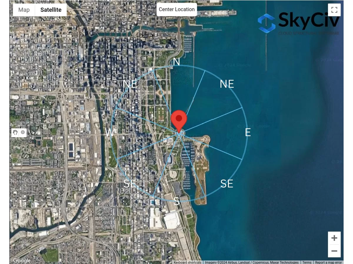
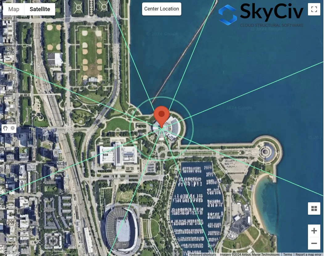
应根据每个风源方向确定暴露类别. 使用示例站点位置 – “1200 S 杜萨布尔湖滨大道, 芝加哥, 的 60605, 美国”, 让我们对每个方向进行分析.
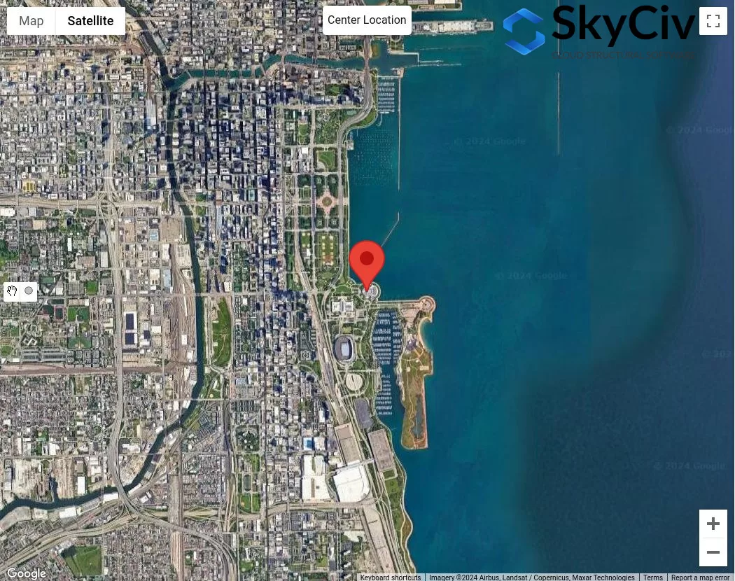
数字 4. 暴露类别分析的样本位置.
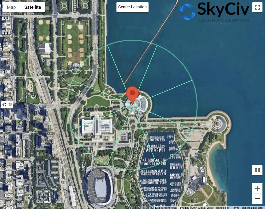
假设结构的平均屋顶高度为 25 英尺 ( \( 20h = 500 英尺 \)), 我们将使用以下程序来检查每个部门的暴露类别:
健康)状况 1. 使用图确定是否暴露 D 3:
使用图 3 – 哪里的距离 \( d_{1} \) 是 5000 英尺 (1524 米), 我们需要检查暴露 D, 其中表面粗糙度 D 在整体上占主导地位 5000 英尺伸展:
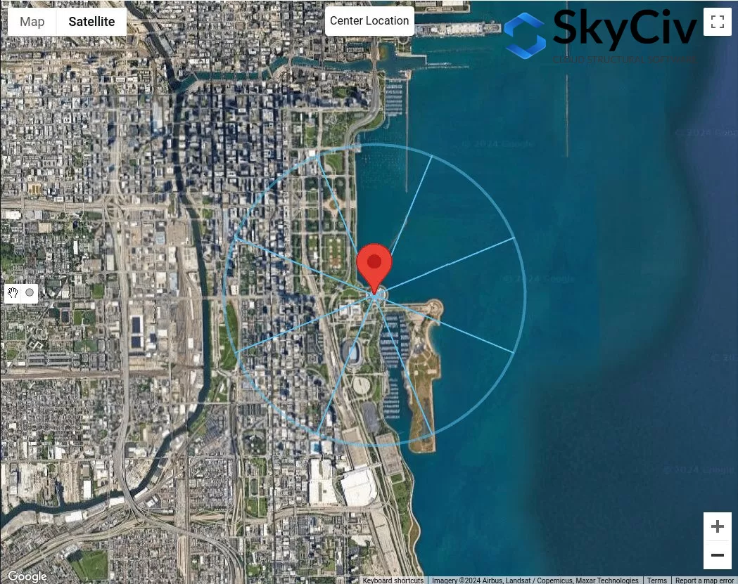
数字 5. 偏移距离 5000 使用图进行暴露 D 检查的现场位置 ft 3.
从图 5, 我们已经可以得出结论,风源方向 ñ, 出生, 和E 整体表面粗糙度为D 5000 英尺伸展. 因此, 这些风源方向是 曝光D.
健康)状况 2. 使用图确定是否暴露 D 2
使用图 4 – 哪里的距离 \( d_{1} \) 是 5000 英尺 (1524 米) 和距离 \( d_{2} \) 等于 600 英尺 (183 米), 我们需要检查暴露 D. 从图 5, 这只适用于SE风源方向:
数字 6. 偏移距离 600 英尺及额外 5000 使用图进行暴露 D 检查的现场位置 ft 4.
风源方向SE, 使用 \( d_{2} = 600 英尺 \), 我们可以认为该截面为表面粗糙度B. 然而, 对于距离 \( d_{1} = 5000 英尺 \), 该部分不是 100% 表面粗糙度D. 因此, SE 不应被视为暴露 D.
健康)状况 3. 使用图确定是否暴露 B 1
使用图 3 – 哪里的距离 \( d_{1} \) 是 1500 英尺 (457 米) 以来 \( H < 30 英尺 \), 我们需要检查暴露 B.
数字 7. 偏移距离 1500 使用图进行暴露 B 检查的现场位置 英尺 3.
从图 7, 我们可以确定风源方向为 NW, w ^, 西南, 和 S 被分类为曝光 B,因为每个方向扇区的表面粗糙度为表面粗糙度 B.
健康)状况 4. 如果条件 1 至 3 不是真的, 因此, 地形为Exposure C.
因此, 风源方向SE, 它被归类为暴露类别 C. 综上所述, 各风源方向的暴露类别如图所示 8 下面.
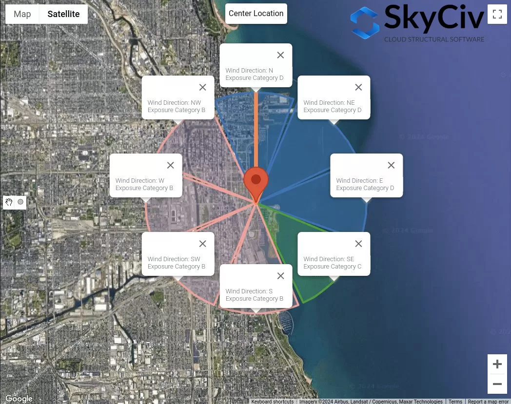
数字 8. 每个风源方向的暴露类别.
这些数据可用于确定最坏的风源方向,如速度压力系数 \( K_{与} \), 地形因素 \( K_{Ť} \), 和阵风效应系数 \( G \) 使用详细计算受暴露类别影响.
NBCC 2015/2020
对于NBCC 2015, 确定场地位置逆风暴露的暴露类别的程序将在第 1 节中讨论 4.1.7.3(5), 取决于地形. 对于每个风源方向, 应从延伸 ±45° 的两个逆风区域进行分析.
数字 9. 每个风源方向的地形扇区.
对于每个部门, 地形类别应根据以下基于Section的定义进行检查 4.1.7.3(5) 全国广播公司 2015:
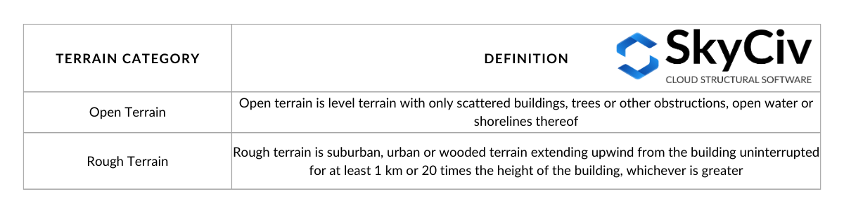
桌子 3. 地形类别的定义如章节中所定义 4.1.7.3(5) 全国广播公司 2015.
可视化表中的选项 3:
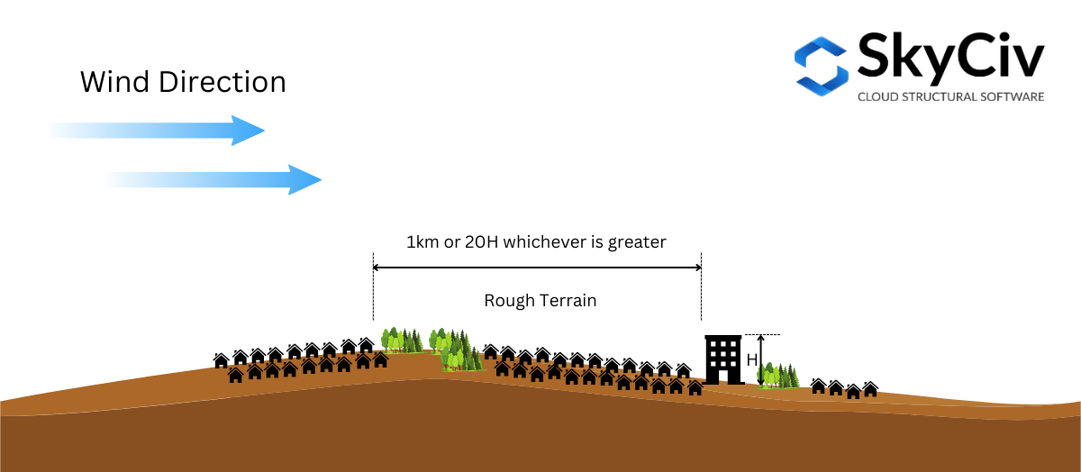
数字 10. 粗糙地形的定义如第 1 节中所定义 4.1.7.3(5) 全国广播公司 2015.
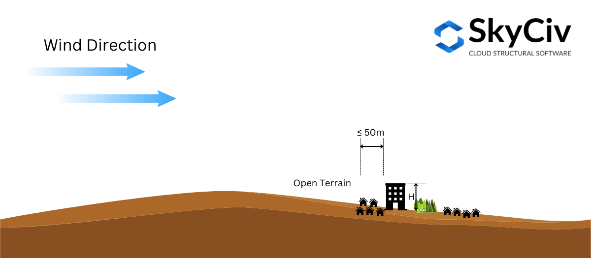
数字 10. 开放地形的定义如章节中所定义 4.1.7.3(5) 全国广播公司 2015.
基于部分 4.1.7.3(5) 全国广播公司 2015, 允许插值 曝光系数 \( C_{Ë} \) 在中间地形. 如果崎岖地形距离建筑物位置大于或等于1公里或 20 乘以结构高度, 以较大者为准, 地形可以认为是 崎岖地形, 如果距离小于 50 米, 它被认为是 开放地形. 除此以外, 曝光系数 \( C_{Ë} \) 按节 4.1.7.3(5) 将根据边界值计算. 这可以在图中可视化 11 下面.
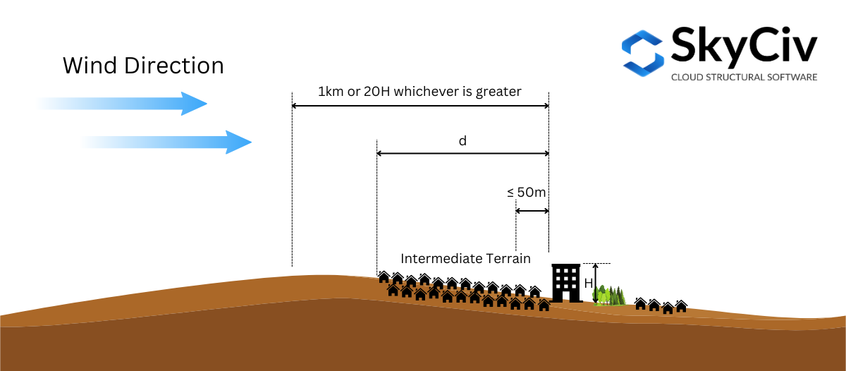
数字 11. 中间地形的定义如第节中所定义 4.1.7.3(5) 全国广播公司 2015.
为了进一步说明这一点, 让我们使用一个示例站点位置 – “657 马斯特斯路东南, 卡尔加里, AB T3M 2B6, 加拿大,” 假设结构高度 \( H \) 是 25 米 ( \( 20高= 500 米 \)).
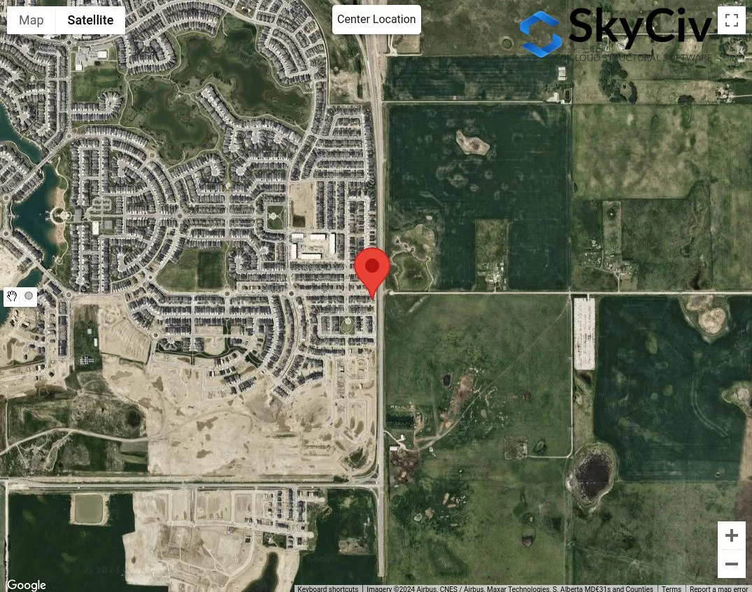
数字 12. 地形类别分析的样本位置.
第一步是对每个风源方向的明显崎岖和开阔地形进行分类. 我们可以画50m和最大 1 公里或 \( 20 H \) 距离站点位置的半径.
数字 13. 根据表确定地形类别的偏移距离为50m和1km 1 定义.
从图 13, 我们可以说风源方向 出生, Ë, 例如林区中的孤立塔 被分类为 地形开阔 由于距场地位置各方向的崎岖地形长度均小于50m. 此外, 用于风源方向 西和西北 可以归类为崎岖地形,因为这些方向的崎岖地形长度大于 1 公里. 对于风源方向 ñ, 我们可以保守地假设开放地形在这个方向上占主导地位. 对于其余的, 南和西南, 我们可以得出结论,这些是中间地形,我们需要测量崎岖地形与场地位置的距离.
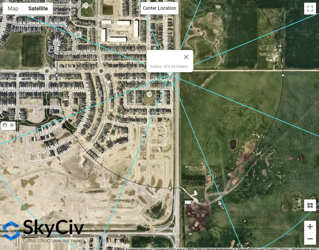
数字 14. 从现场位置测量的西南风源方向的近似崎岖地形长度等于 574 米.
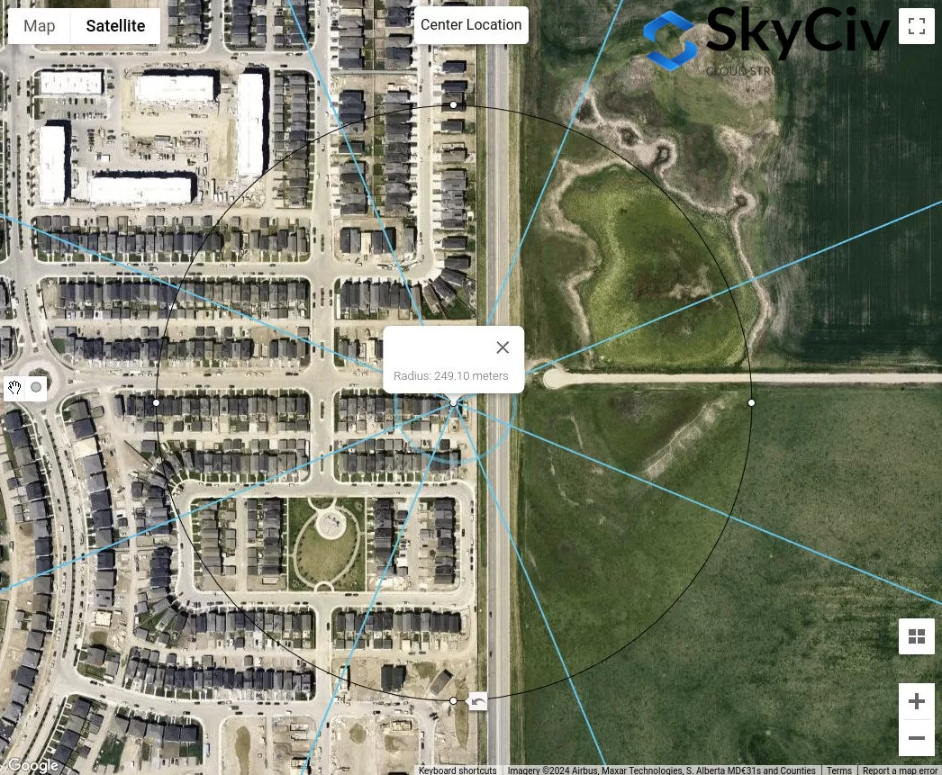
数字 15. 从现场位置测量的 S 风源方向的近似崎岖地形长度等于 249 米.
从上面的分析来看, 开放地形的风源方向肯定会产生保守值. 然而, 如果所有风源方向都分类为中间地形, 上述过程是如何确定每个方向适当的地形类别.
AS / NZS 1170.2 (2021)
对于AS / NZS 1170.2, 与上述参考文献相同的程序适用于确定场地位置的逆风暴露的地形类别. 这将在章节中讨论 4.2 AS / NZS的 1170.2 (2021). 对于每个风源方向, 应从延伸 ±45° 的两个逆风区域进行分析. 各地形类别的定义如下所示 4.2.1 AS / NZS的 1170.2 (2021):
桌子 4. 地形类别的定义如章节中所定义 4.2.1 AS / NZS的 1170.2 (2021).
在确定某个方向的地形类别时, 滞后距离等于 \( 20 与 \) 从结构位置来看应忽略不计. 从此, 偏移距离 (平均距离) 的 500 或 \( 40 z), 以较大者为准, 应如图所示使用 16 下面. 的 \( 与 \) 值等于平均屋顶高度, \( H \), 当它小于或等于 25 米. 在此平均距离内可能有多个地形类别, 因此, 应使用线性插值来确定 \( M_{与,猫} \) 价值观, 取决于每个地形类别的长度, 如图所示 4.1 AS / NZS的 1170.2 (2021). 在这篇文章中, 我们只考虑平均距离内的同质地形类别.
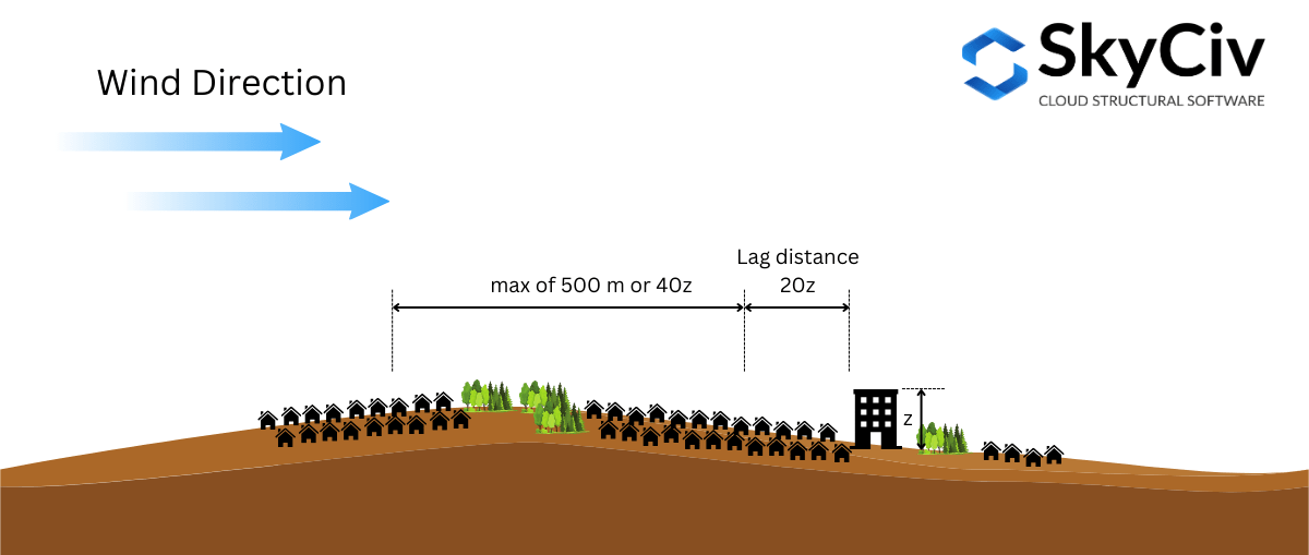
数字 16. 用于根据 AS/NZS 确定地形类别的距离图示 1170.2 (2021).
为了进一步说明这一点, 让我们使用一个示例站点位置 – 纬度: 32°43'46″S朗: 151°31’47″Ë – 假设平均屋顶高度 \( H \) 是 10 米 ( 哪里 \( 20z = 20h = 200 米 \) 和 \( 40z = 400 米 \)).
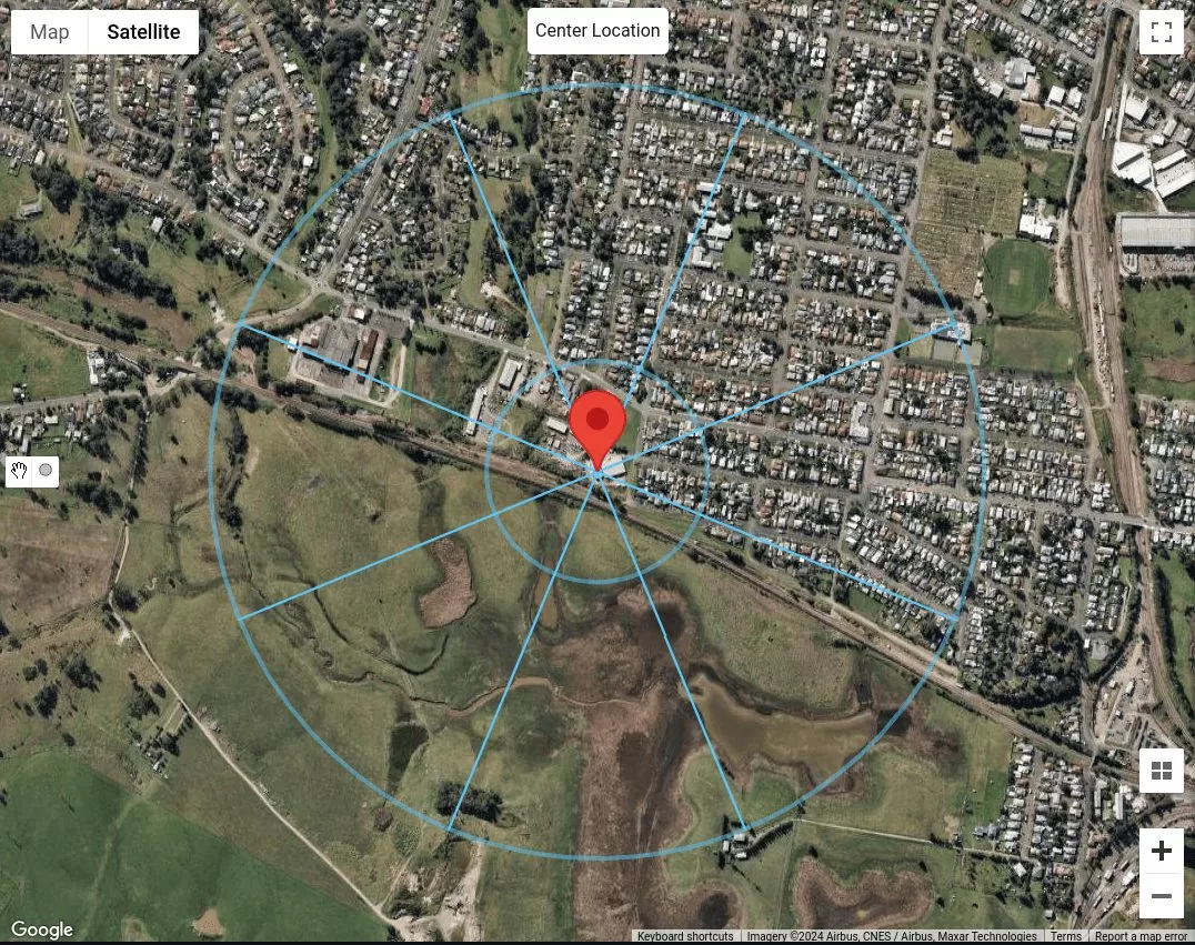
数字 17. 滞后距离等于的站点位置 200 m 和平均距离等于 500 m 代表每个风源方向.
由于我们仅将地形类别视为在整个 500m 或 \( 40与 \) 距离, 我们已经可以对每个风源方向进行分类. 假设N上的建筑物, 东北和东, 是建筑物 5 至 10 米高, 我们可以将它们分类为地形类别 3 (TC3) 如表所示 4. 对于风源方向 SE, 小号, 西南, 和W, 因为这些都是没有障碍物的草原, 我们可以将它们分类为地形类别 1 (TC1). 最后, 风源方向 NW, 我们可以推断出多于两个但少于 10 每公顷建筑物, 房屋分散. 因此, 我们可以将其归类为地形类别 2.5 (TC2.5).
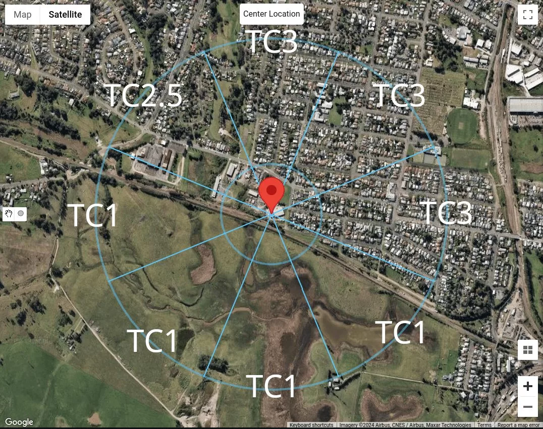
数字 18. 我们的样本位置每个风源方向的地形类别分类摘要.
使用 SkyCiv 负载生成器
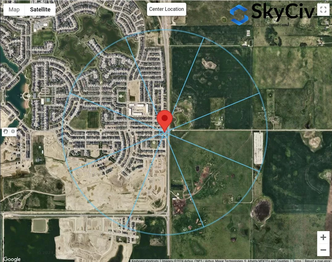
在 SkyCiv Load Generator 版本 v4.7.0 中, 引入新的地图工具 – 测量距离 和 距离半径 工具.
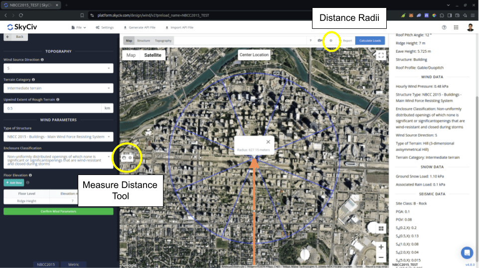
数字 19. SkyCiv Load Generator 引入距离测量工具.
的 测量距离 工具用于从地图中单击的点生成圆并以米为单位显示其半径. 这条路, 您可以测量距正在分析的位置(某些位置)的距离. 这可用于 NBCC 中的测量 2015 为了 崎岖地形的逆风范围 用于计算 曝光系数 \( C_{Ë} \). 单击生成的圆圈会将其从地图上清除.
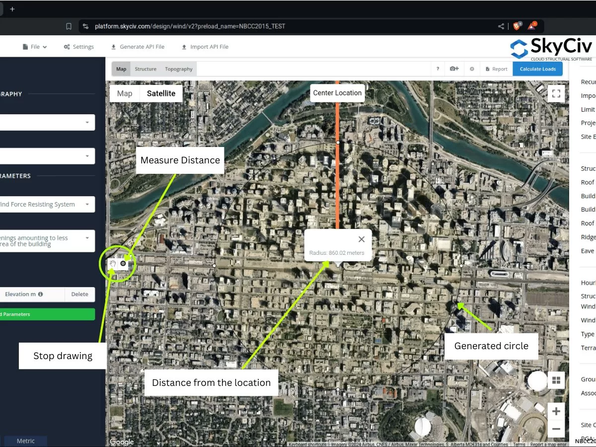
数字 20. 测量距离工具,可创建距位置的偏移并显示引入 SkyCiv Load Generator 的距中心的半径/偏移距离.
另一方面, 的 距离半径 的引入,以便用户可以为每个风源类别绘制距位置指定距离的圆圈. 这是一个切换按钮,用于在地图上显示或隐藏距离半径, 以站点位置为圆心.
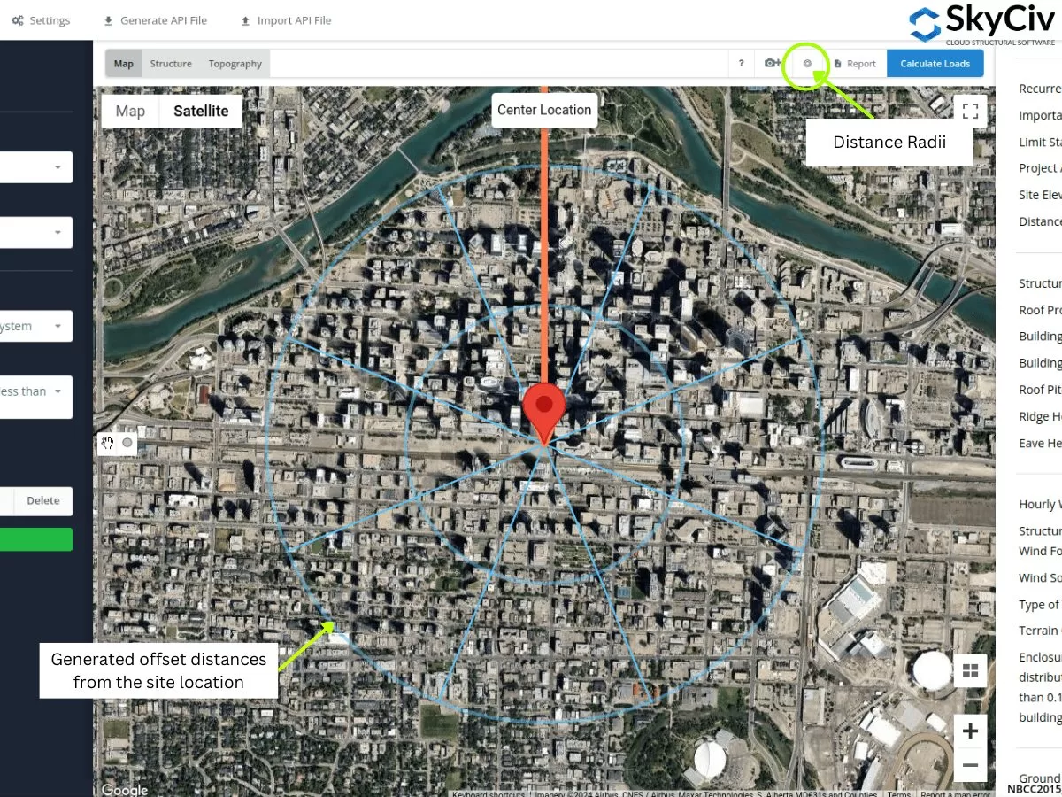
数字 21. 距离半径工具,指定距 SkyCiv Load Generator 引入的站点位置的偏移距离.
打开设置后可以编辑半径值.
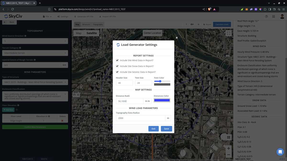
数字 22. 设置中的选项可编辑 SkyCiv 负载生成器中距离半径工具的距离.
请注意,用户必须编辑距离值,因为软件不会自动计算这些距离值. 将其用于 ASCE 7 和NBCC, 应采用每个风源方向的最坏暴露或地形类别. 关于在 AS/NZS 中使用它 1170.2 (2021), 该软件不使用半径值来计算平均值 \( M_{与,猫} \) 价值观. 代替, 平均距离用作我们可以分配同质地形类别的适用范围, 对每个风源方向采用最差类别.
从上面讨论的部分来看, 您可以使用这些新工具来确定每个风源方向的暴露或地形类别. 通过以上程序可以让您快速对各个风源方向进行地形分类. 使用 GIS 和 AI 工具, 您可以进一步检查我们上面针对每个风源方向使用的标准,可以获得更好、更高效的结果.

结构工程师, 产品开发
土木工程硕士
领英
参考资料:
- 建筑物和其他结构的最低设计负荷. (2017). 轴/六 7-16. 美国土木工程师学会.
- 加拿大国家研究委员会. (2015). 加拿大国家建筑法规, 2015. 加拿大国家研究委员会.
- 澳大利亚标准 (2021), 结构设计行动. 部分 2 风动作, 澳大利亚/新西兰标准 AS/NZS1170.2:2021, 澳大利亚标准, 悉尼, 新南威尔士州, 欧洲.
- 你可以通过这个查看我们的 API 文档