En utilisant le “Afficher les entrées de vent de conception pour toutes les directions” dans Générateur de Charge
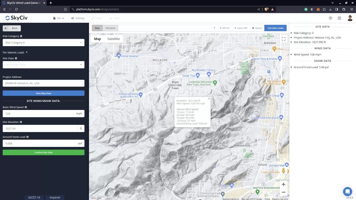
L'analyse du site est cruciale dans les calculs de charge de vent. En effectuant cette analyse, nous pouvons déterminer la pire direction de la source de vent pour générer la vitesse et les pressions du vent de conception les plus élevées.
Dans le générateur de charge SkyCiv, cela peut être fait en cliquant sur le bouton « Afficher les entrées de vent de conception pour toutes les directions ». Par contre, ceci n'est disponible que pour l'ASCE 7, NSCP 2015, et AS / NZS 1170 pour l'instant. Bientôt, nous ajouterons les autres codes de référence pour faciliter votre processus de conception.
Essayez notre Générateur de charge SkyCiv!
Données de site pour le calcul de la charge de vent.
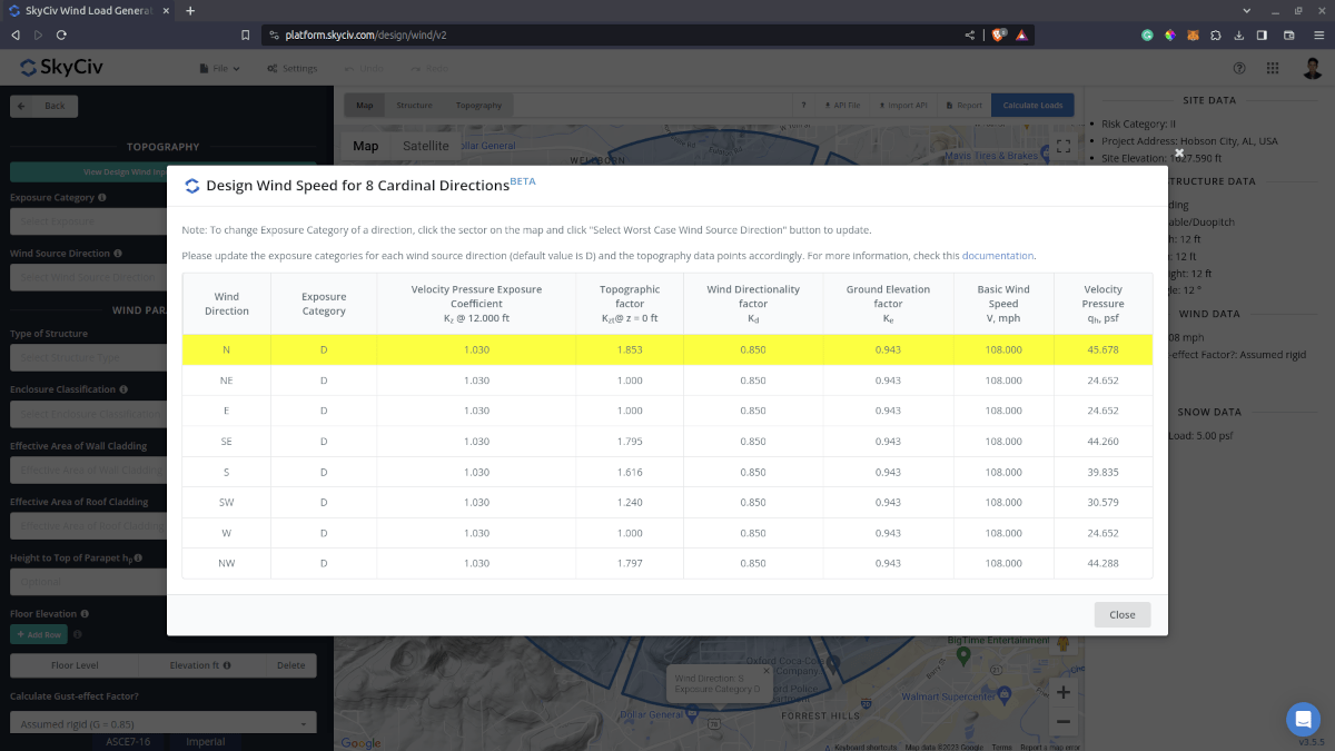
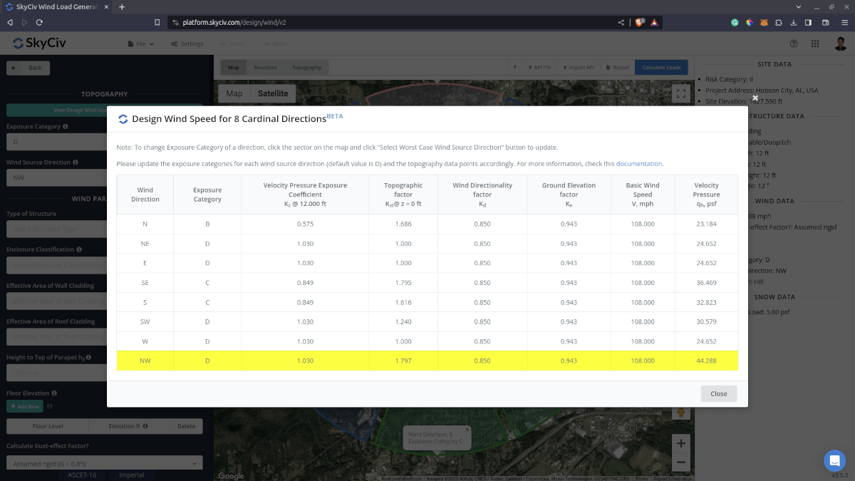
En cliquant sur le bouton « Afficher les entrées de vent de conception pour toutes les directions » au-dessus de l'image de la carte, il générera les secteurs de terrain pour chaque direction. Il générera les paramètres pour chaque direction et calculera les pressions de vitesse correspondantes. Notez que le rayon des secteurs est égal à 2 miles pour les unités impériales et 2 kilomètres pour les unités métriques.
Pour ASCE 7 et NSCP 2015, la catégorie d'exposition par défaut est D. Cela affectera la valeur du coefficient d'exposition à la pression de vitesse \({K}_{z} \) car cela dépend de la catégorie d'exposition de la direction au vent. Ce logiciel \({K}_{z} \) la valeur sera calculée à 15 ft pour les unités impériales et 4,5 m pour les unités métriques. Ceci sert uniquement à comparer la pression de vitesse calculée qui diffère pour chaque direction.. Ce facteur sera ensuite recalculé à la hauteur moyenne du toit, \( h \), pour la pression du vent de conception. De plus, le facteur topographique, \({K}_{zt} \), est calculé à \( z = 0 m ) car c'est l'endroit où l'effet maximal de la topographie peut être considéré.
Valeurs initiales pour les données de direction de la source de vent dans le cas le plus défavorable.
Les secteurs de catégorie de terrain/exposition modifiables générés dans la carte.
Pour AS / NZS 1170, la catégorie de terrain par défaut est 1. Cela affectera la valeur du multiplicateur de terrain/hauteur., \({M}_{z} \), car cela dépend de la catégorie de terrain de la direction au près. Ce \({M}_{z} \) le facteur est calculé à 3 m de hauteur pour comparaison avec toutes les autres directions. Ce facteur sera ensuite recalculé à la hauteur moyenne du toit, \( h \), pour la pression du vent de conception. De plus, chaque direction a un multiplicateur de direction correspondant, \({M}_{d} \), ce qui a certainement un impact sur la vitesse du vent de conception. De plus, le multiplicateur topographique, \({M}_{t} \) est calculé à \(z = 0 \) car c'est l'endroit où l'effet maximum peut être considéré.
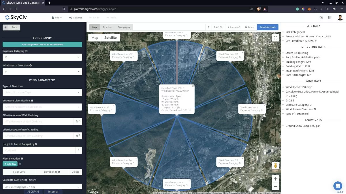
Pour mettre à jour chaque catégorie d'exposition ou de terrain, il vous suffit de cliquer sur les secteurs à l'intérieur de Google Map. Il changera de couleur pour indiquer que la catégorie d'exposition/terrain est mise à jour et affichera également les informations sur l'exposition ou la catégorie de terrain sélectionnée.. Après ce processus, cliquez simplement à nouveau sur le bouton « Sélectionner la direction de la source de vent dans le pire des cas » pour mettre à jour les valeurs dans le tableau..
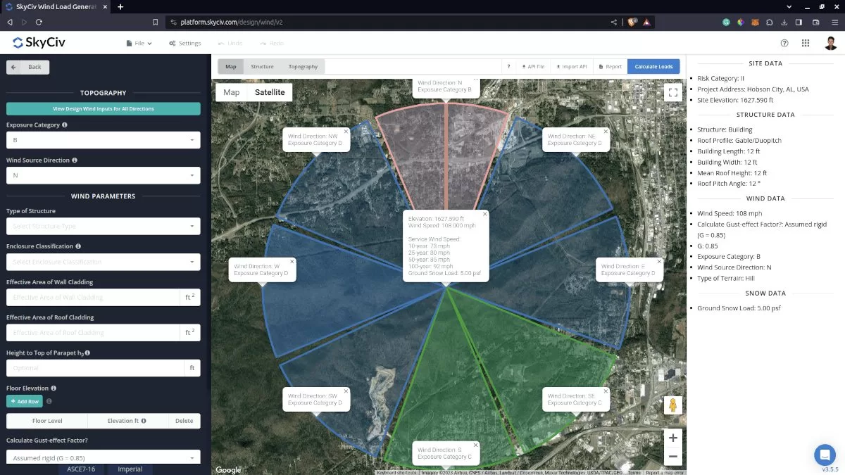
La catégorie de terrain mise à jour pour chaque direction.
Il vous suffit de re-cliquer à nouveau sur le bouton « Sélectionner la direction de la source de vent dans le pire des cas » pour vérifier les modifications.. La valeur de pression de vitesse maximale dans le tableau sera mise en surbrillance et pourra être cliquée pour charger automatiquement la direction et la catégorie d'exposition/terrain correspondante dans l'onglet Données du site..
Les paramètres mis à jour pour déterminer la direction de la source du vent dans le cas le plus défavorable.
Aussi, vous pouvez revérifier et modifier le facteur/multiplicateur topographique calculé sur le graphique d'élévation du sol par direction. Ce facteur sera ensuite enregistré et utilisé dans le recalcul des données du tableau pour déterminer la direction de la source de vent la plus défavorable..
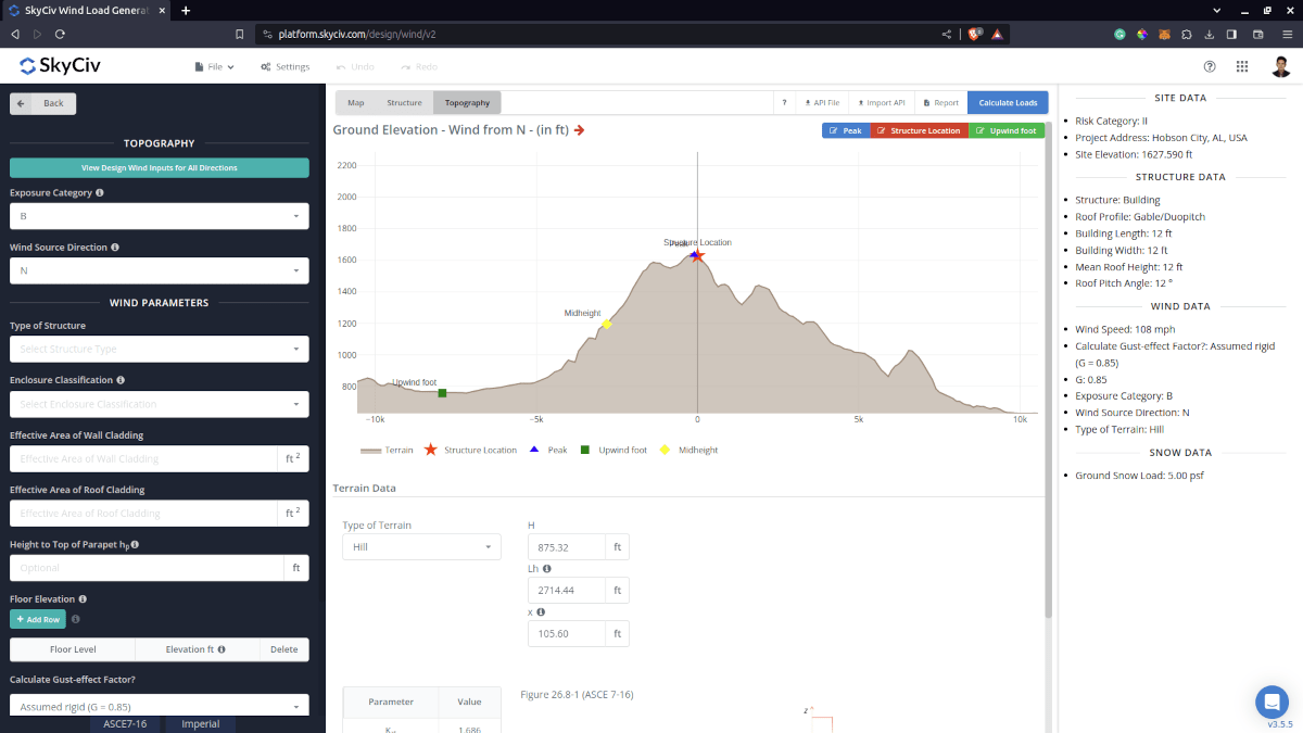
La carte d'élévation où vous pouvez modifier le facteur/multiplicateur topographique par direction de la source de vent dans l'analyse du site.
Une fois que vous avez modifié les données d'altitude par direction du vent, il vous suffit de cliquer à nouveau sur le bouton « Afficher les entrées de vent de conception pour toutes les directions » pour vous montrer les changements dans la vitesse/pression du vent..
La pression de vitesse mise à jour après avoir modifié le facteur topographique dans la carte d'élévation.
Tout ce processus en quelques clics! Profitez de cette fonctionnalité en créant un compte professionnel ou en achetant le module générateur de charge individuel!
Pour des ressources supplémentaires, voir les liens ci-dessous vers notre solution personnalisée pour panneau solaire créée pour MT Solar à l'aide de l'API SkyCiv:
- Introduction à SkyCiv Load Generator
- Effets de la topographie sur la charge du vent
- AS / NZS 1170.2 Exemple de calcul de la charge de vent
- ASCE 7-10 Exemple de calcul de la charge de vent
- ASCE 7-10 Exemple de calcul de la charge de vent
- EN 1991-1-4 Exemple de calcul de la charge de vent
- ASCE 7-16 Exemple de calcul de la charge du vent pour un bâtiment en forme de L
- EST 875-3 Exemple de calcul de la charge de vent
- Charges de vent et de neige pour les panneaux solaires au sol – ASCE 7-16
- Calcul de la charge de vent pour les panneaux – FR 1991