standalone.loads
The standalone.loads namespace provides functions to manage sessions for wind speed, wind design and snow calculations.
standalone.loads.start#
At the beginning of every API session, the session must be started. This function must be the first function in the array. This initiates a session and will return a session_id which can be used in subsequent calls made in the following 30 minutes to skip the verification process, thereby dramatically reducing the time to response.
important
The start function must always be the first function even if session_id is provided.
| Key | Type | Accepts | Description | Default |
|---|---|---|---|---|
keep_open | boolean | true, false | If the session should be kept on standby. If true, subsequent calls to the API using the session_id provided from the first call in lieu of key, will be 4-8x faster. | false |
After authenticating using the API key, the response object will contain some useful information. The session_id key can be used to make further calls to the same session, skipping authentication. The session_expiry_time provides an approximate Unix time until the session expires. After this, the user must re-authenticate using their API key.
tip
The returned session_id can be provided in the auth object of subsequent calls to make the request faster.
standalone.loads.getCountryDesignCodes#
To get the supported design codes with the corresponding countries for each load calculation:
Some data output were removed for brevity.
standalone.loads.getSiteData#
Using this function, you can get the available site data for specified location with the corresponding design code using minimal input.
Relevant components#
- The
site_dataobject - (Optional)
api_versionint
The response will return the site details, site wind speed, site snow load, and site seismic data, whichever is available.
Some data output were removed for brevity.
Parameters#
The following Objects are required parameters for the above functions.
site_data#
Refer to definition in standalone.loads.getLoads
Common properties for all design codes#
| Key | Type | Description |
|---|---|---|
design_code | string | Which design code is this based on: as1170, asce7-10, asce7-16, asce7-22, en1991, nbcc2015, nbcc2020, is875, nscp2015, cfe-viento, asce7-22 |
project_address | string | The site location. This will use Google Maps to search the address and select the first option. |
lat | float | Latitude of site location (used instead of project_address). E.g. 41.878100 for Chicago |
lng | float | Longitude of site location (used instead of project_address). E.g. -87.629800 for Chicago |
Design code specific properties#
| Key | Type | Design Code | Description/Options |
|---|---|---|---|
risk_category | string | ASCE 7 | I, II, III, IV |
occupancy_category | string | NSCP 2015 | I, II, III, IV, V |
sls_and_uls | object | AS/NZS 1170 | object containing country, design_working_life, importance_level |
sls_and_uls.country | string | AS/NZS 1170 | australia or new_zealand Required for SLS and ULS wind speeds |
sls_and_uls.design_working_life | string | AS/NZS 1170 | construction_equipment, 5_years, 25_years, 50_years, 100_years, less_than_6_months (NZ only) Required for SLS and ULS wind speeds |
sls_and_uls.importance_level | string | AS/NZS 1170 | Number between 1, 5 specifying importance level Required for SLS and ULS wind speeds |
site_class | string | ASCE 7-16 | A, B, C, D, D-default, E |
site_class | string | ASCE 7-22 | A, B, BC, C, CD, D, DE, E |
site_class | string | NBCC 2020 | A, B, C, D, E |
standalone.loads.getLoads#
Using the below variables, users can get the wind speed, snow loads and wind pressures from ASCE 7, AS/NZS 1170, NBCC, Eurocode Design Standards, IS 875, NSCP 2015, and Comisón Federal de Electricidad (CFE Viento).
standalone.loads.getLoadsRelevant components#
- The
site_dataobject - The
building_dataobject - (Optional)
project_detailsobject - (Optional)
site_analysisobject - (Optional)
api_versionint
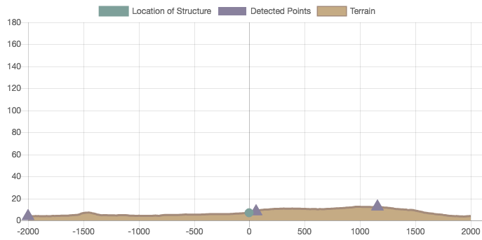
The response will return design wind speed, elevations, topography, wind and snow pressures and confirm the address of the site location under the key wind_speed. In addition to this, if the terrain data is requested (user provides wind_direction and exposure keys) it will also return topography data:
Here is a sample of the elevation image that is returned when elevation_img: true :
Parameters#
The following Objects are required parameters for the above functions.
site_data#
Get wind speed from site location, based on ASCE 7-10, ASCE 7-16, ASCE 7-22 (wind and seismic data), AS/NZS 1170, NBCC 2015, NBCC 2020, EN 1991, IS 875, NSCP 2015, and Comisón Federal de Electricidad (CFE Viento).
Common properties for all design codes#
| Key | Type | Description |
|---|---|---|
design_code | string | Which design code is this based on: as1170, asce7-10, asce7-16, asce7-22, en1991, nbcc2015, nbcc2020, is875, nscp2015, cfe-viento, asce7-22 |
project_address | string | The site location. This will use Google Maps to search the address and select the first option. |
wind_direction | string | Wind direction (going to). N, NE, E, SE, S, SW, W, NW. |
lat | float | Latitude of site location (used instead of project_address). E.g. 41.878100 for Chicago |
lng | float | Longitude of site location (used instead of project_address). E.g. -87.629800 for Chicago |
Design code specific properties#
| Key | Type | Design Code | Description/Options |
|---|---|---|---|
risk_category | string | ASCE 7 | I, II, III, IV |
exposure | string | ASCE 7/NSCP 2015 | Required for topography result B, C, D |
ari | integer | AS/NZS 1170 | Annual Recurrence Interval (in years)1, 5, 10, 20, 25, 50, 100, 200, 250, 500, 1000, 2000, 2500, 5000, 10000 |
sls_and_uls | boolean or object | AS/NZS 1170 | object containing country, design_working_life, importance_level Set to false - if ari is used |
sls_and_uls.country | string | AS/NZS 1170 | australia or new_zealand Required for SLS and ULS wind speeds |
sls_and_uls.design_working_life | string | AS/NZS 1170 | construction_equipment, 5_years, 25_years, 50_years, 100_years, less_than_6_months (NZ only) Required for SLS and ULS wind speeds |
sls_and_uls.importance_level | string | AS/NZS 1170 | Number between 1, 5 specifying importance level Required for SLS and ULS wind speeds |
wind_region | string | AS/NZS 1170 | For user-defined wind region (Optional)A0, A1, A2, A3, A4, A5, B1, B2, C, D, NZ1, NZ2, NZ3, NZ4 |
recurrence_interval or ari | string | NBCC 2015/NBCC 2020 | Annual Recurrence Interval: 10_years, 50_years |
importance_level | string | NBCC 2015/NBCC 2020 | low, normal, high, post_disaster |
limit_state | string | NBCC 2015/NBCC 2020 | SLS, ULS |
importance_category | string | IS 875 | I, II, III, IV |
structure_class_is875 | string | IS 875 | I, II, III, IV |
occupancy_category | string | NSCP 2015 | I, II, III, IV, V |
return_period | string | CFE Viento | 10-anos, 50-anos, 200-anos |
barometric_pressure | float | CFE Viento | Default value is 760 mm Hg |
ambient_temperature | float | CFE Viento | Default value is 25 deg. Celcius |
Additonal parameters for user-defined wind speed or ground snow load#
| Key | Type | Design Code |
|---|---|---|
wind_speed_override | float | ASCE 7, AS/NZS 1170, EN 1991, IS 875, NSCP 2015 Wind Load Calculation |
hourly_wind_pressure_override | float | NBCC 2015/NBCC 2020 Wind Load Calculation |
snow_load_override | float | ASCE 7, AS/NZS 1170, EN 1991, NBCC 2015/NBCC 2020 Snow Load Calculation |
min_roof_snow_load | float | ASCE 7 Snow Load Load Calculation for override on minimum snow load pm value |
Additonal site_data parameters for seismic load (ASCE 7-16/ASCE 7-22) - site_data.site_seismic_data#
| Key | Type | Design Code |
|---|---|---|
site_class | string | ASCE 7-16: A, B, C, D, D-default, EASCE 7-22: A, B, BC, C, CD, D, DE, E |
site_seismic_data | object | User-defined site seismic parameters (optional): sd1, s1, sds, tl |
site_seismic_data.tl | float | Long-period transition period |
site_seismic_data.sds | float | Design spectral response acceleration parameter at short periods |
site_seismic_data.sd1 | float | Design spectral response acceleration parameter at 1s period |
site_seismic_data.s1 | float | Mapped max. considered earthquake spectral response acceleration parameter |
Design code specific site_data.topography properties#
| Key | Type | Design Code | Description/Options |
|---|---|---|---|
terrain_category | string | AS/NZS 1170 | CAT1, CAT2, CAT2.5, CAT3, CAT4 |
snow_region | string | AS/NZS 1170 | For user-defined snow region (optional) For Australia: AN, AC, AS, AT For New Zealand: N1, N2, N3, N4, N5 |
snow_area_classification | string | AS/NZS 1170 | For user-defined snow area classification (optional): alpine, sub-alpine |
snow_terrain_class | integer | AS/NZS 1170 | 1, 2, 3 |
snow_area_classification | string | NBCC 2015/NBCC 2020 | rural, exposed-north-treeline |
country | string | EN 1991 | Germany, United Kingdom, France... Required for additional parameters (season_month, wind_direction, terrain_category |
season_month | string | EN 1991 | For Belgium, France, UK, and Ireland For temporary structures: 1 month: January, February, ... 2 months (UK and Ireland only): January-February, March-April, ...4 months (UK and Ireland only): November-February, December-March, ... 6 months (UK and Ireland only): October-March, April-September, ... For permanent structures: Long-term |
wind_direction | string or integer | EN 1991 | The angle of which the wind is going to, referenced from N in clockwise direction. Use Any for worst caseFor Belgium, Poland, United Kingdom, Ireland, and France: (in degrees). Increments of 30° ranging from 0 - 360 For other countries: N, NE, E, SE, S, SW, W, NW |
en1991_NF_coz_procedure | integer | EN 1991 (NF) | For France and French territories: The procedure in calculating orography factor: 1, 2 |
terrain_category | string | EN 1991 | For UK and Ireland:0 for Sea I or II for Country III or IV for Town For France: 0 II IIIa IIIb IV For Netherlands: 0 II III Other countries: I II III IV |
distance_inside_town | float | EN 1991 | Required for UK and Ireland. Default value is 20 |
distance_from_shore | float | EN 1991 | Required for UK and Ireland. Can be obtained from server if wind direction is not equal to Any. Default value is 100 |
displacement_height | float | EN 1991 | Required for UK and Ireland. Default value is 0 |
terrain_category | string | IS 875 | 1, 2, 3, 4 |
terrain_category | string | CFE Viento | 1, 2, 3, 4 |
- ASCE 7-16
- AS/NZS 1170.2
- NBCC 2015
- EN 1991
- IS 875
- NSCP 2015
- CFE Viento
standalone.loads.getLoadsbuilding_data#
Generate wind pressures or snow loads based on building parameters. These parameters have minor differences between design codes. If you need any assistance, please email us at [email protected].
Options for Structure#
| building_data.structure | Remarks |
|---|---|
building | Default value |
freestanding_wall | ASCE 7 and AS/NZS 1170 only |
truss_tower | ASCE 7 only |
rooftop_equipment | ASCE 7-16/ASCE7-22 only |
solar_panel | ASCE 7 and AS/NZS 1170 only |
signboard | EN 1991 only |
pole | EN 1991 only |
open_frames | ASCE 7-16/ASCE7-22 only |
circular-bin | ASCE 7-16/ASCE7-22 and AS/NZS 1170 only |
Options for ASCE 7, AS/NZS 1170, NBCC 2015/NBCC 2020, NSCP 2015#
| building_data.roof_profile | building_data.wind_parameters.enclosure | building_data.wind_parameters.wind_blockage |
|---|---|---|
gable | enclosed, partially-enclosed, partially-open | |
monoslope | enclosed, partially-enclosed, partially-open | |
hip | enclosed, partially-enclosed, partially-open | |
pitched | open | For ASCE 7/NSCP 2015/CFE Viento: clear, obstructed For AS/NZS 1170: empty, blocked |
troughed | open | For ASCE 7/NSCP 2015/CFE Viento: clear, obstructed For AS/NZS 1170: empty, blocked |
open-monoslope | open | For ASCE 7/NSCP 2015/CFE Viento: clear, obstructed For AS/NZS 1170: empty, blocked |
| building_data.wind_parameters.structure_type | Description |
|---|---|
mwfrs | Main Wind Force Resisting System |
cladding | Components and Cladding |
Additonal wind load parameter for user-defined options for ASCE 7-10, ASCE 7-16, and NSCP 2015#
| Key | Type |
|---|---|
| building_data.wind_parameters.gust_effect_factor_override | float |
Options for IS 875#
| building_data.roof_profile | building_data.wind_parameters.enclosure |
|---|---|
gable | enclosed, medium-opening, large-opening |
monoslope | enclosed, medium-opening, large-opening |
hip | enclosed, medium-opening, large-opening |
pitched | open |
open-monoslope | open |
Options for AS/NZS 1170, EN 1991, IS 875, and CFE Viento#
| building_data.wind_parameters.structure_type | building_data.roof_profile |
|---|---|
building | gable, monoslope, hip |
free_roof | For EN 1991: pitched, open-monoslope For AS/NZS 1170 and CFE Viento: pitched, open-monoslope, troughed |
For AS/NZS 1170 and IS 875: cladding | gable, monoslope, hip, pitched, open-monoslope, troughed |
User-defined parameter for AS/NZS 1170.2 (2021)#
| Parameter | Description |
|---|---|
building_data.wind_parameters.Mh | User-defined input for Hill-shape multiplier, Mh, for the selected wind source direction and default value for all wind direction (if site_analysis.hillshape_multiplier_all_direction is not defined) |
building_data.wind_parameters.Mlee | User-defined input for Lee multiplier, Mlee, for the selected wind source direction and default value for all wind direction (if site_analysis.lee_multiplier_all_direction is not defined) |
building_data.wind_parameters.Ms | User-defined input for Shielding multiplier, Ms, for all wind direction |
building_data.wind_parameters.Md | User-defined input for Wind Direction multiplier, Md, for the selected wind source direction and default value for all wind direction (if site_analysis.terrain_category_all_directions is not defined) |
building_data.wind_parameters.Mc | User-defined input for Climate Change multiplier, Mc, for all wind direction |
building_data.wind_parameters.Mz_cat | User-defined input for Terrain Height multiplier, Mz,cat, for all wind direction at height h |
building_data.freestandingwall_dimensions for ASCE 7-16 and AS/NZS 1170.2 Freestanding Wall Wind Load Calculation#
| Parameter | Description |
|---|---|
freestandingwall_dimensions.ground_to_top | Structure height from ground to top of wall |
freestandingwall_dimensions.wall_width | Wall Width |
freestandingwall_dimensions.wall_height | Wall Height |
freestandingwall_dimensions.ratio_of_solid_area_to_gross | Solidity ratio of wall |
freestandingwall_dimensions.length_of_return_corner | For ASCE 7-16: Length of return corner |
wind_parameters.wall_surface_type | For AS/NZS 1170: with-ribs (default), with-corrugations, smooth, |
wind_parameters.structure_type | freestandingwall |
building_data.open_frames_dimensions for ASCE 7-16/ASCE 7-22 Open Signs/Frames Wind Load Calculation#
| Parameter | Description |
|---|---|
open_frames_dimensions.ground_to_top | Structure height from ground to top of open frames |
open_frames_dimensions.ratio_of_solid_area_to_gross | Ratio of solid area to the gross area |
open_frames_dimensions.structural_members | Array of member data object: member_id, section_type, section_depth, orientation, member_elevation_bottom, member_elevation_top Refer to Load Gen UI for options |
wind_parameters.structure_type | open-frames |
building_data.circular_bin_dimensions for ASCE 7-16/ASCE 7-22 Tanks/Silos/Circular Bin Wind Load Calculation#
| Parameter | Description |
|---|---|
circular_bin_dimensions.D | For ASCE 7: Diameter of Circular Bin/Structure |
circular_bin_dimensions.H | For ASCE 7: Solid Cylinder Height |
circular_bin_dimensions.C | For ASCE 7: Clearance Height above ground |
circular_bin_dimensions.Z | For ASCE 7: Ground to Centroid of Structure |
circular_bin_dimensions.b | For AS/NZS 1170: Diameter of Circular Bin/Structure |
circular_bin_dimensions.c | For AS/NZS 1170: Solid Cylinder Height |
circular_bin_dimensions.Z | For AS/NZS 1170: Clearance Height above ground |
circular_bin_dimensions.roof_pitch_angle | Roof Pitch Angle |
circular_bin_dimensions.configuration | Configuration: isolated, grouped (ASCE 7 only) |
circular_bin_dimensions.number_of_tanks | (Optional) Number of Tanks: default value is 1.0 |
building_data.wind_parameters for ASCE 7-16/ASCE 7-22 and AS/NZS 1170 Tanks/Silos/Circular Bin Wind Load Calculation#
| Parameter | Description |
|---|---|
wind_parameters.structure_type | circular-bin |
wind_parameters.enclosure | For ASCE 7: Enclosure Classification: enclosed, partially-enclosed, partially-open |
wind_parameters.surface_type | For ASCE 7: Surface Type: moderately-smooth, rough, very-rough |
wind_parameters.wall_cladding_area | For ASCE 7: Array values of wall component area (for grouped), e.g. [10,20,30] |
wind_parameters.roof_cladding_area | Array values of roof component area, e.g. [10,20,30] |
building_data.seismic_parameters for ASCE 7-16 Seismic Load Calculation#
| Parameter | Description |
|---|---|
seismic_parameters | Object with parameters required: structure_height, R, structure_system, weights Optional: Ct, x |
seismic_parameters.structure_height | Structure height to be used in calculating the approximate fundamental period of the structure |
seismic_parameters.R | Response modification factor |
seismic_parameters.redundancy_factor | Redundancy factor (default value is 1.0) |
seismic_parameters.structure_system | For determining Ct and x Options are: steel-mrf, concrete-mrf, steel-eccentrically-braced, steel-buckling-restrained, others |
seismic_parameters.weights | Array of object with the following: level, elevation (in ft - imperial or m - metric), weight (in kips - imperial or kN - metric) |
seismic_parameters.Ct | (Optional) User-defined Ct for calculating the approx. fundamental period of the structure |
seismic_parameters.x | (Optional) User-defined x for calculating the approx. fundamental period of the structure |
building_data.seismic_parameters for NZS 1170.5 Seismic Load Calculation#
| Parameter | Description |
|---|---|
seismic_parameters | Object with parameters required: structure_height, R, structure_system, weights, Ca, Cv |
seismic_parameters.return_period | For calculating return period factor |
seismic_parameters.site_subsoil_class | Site Subsoil Class Options are: A, B, C, D, D-default, E |
seismic_parameters.T1 | Largest translational period in the direction being considered |
seismic_parameters.Sp | Structural performance factor. Default value is equal to 1.0 |
seismic_parameters.mu | Structural ductility factor. Default value is equal to 1.0 |
seismic_parameters.T1_x | (Optional) For 2-direction analysis. Largest translational period in the X-direction |
seismic_parameters.Sp_x | (Optional) For 2-direction analysis. Structural performance factor. Default value is equal to 1.0 |
seismic_parameters.mu_x | (Optional) For 2-direction analysis. Structural ductility factor. Default value is equal to 1.0 |
seismic_parameters.T1_z | (Optional) For 2-direction analysis. Largest translational period in the Z-direction |
seismic_parameters.Sp_z | (Optional) For 2-direction analysis. Structural performance factor. Default value is equal to 1.0 |
seismic_parameters.mu_z | (Optional) For 2-direction analysis. Structural ductility factor. Default value is equal to 1.0 |
seismic_parameters.weights | Array of object with the following: level, elevation (in m), weight (in kN) |
seismic_parameters.Z | (Optional) User-defined hazard factor, Z |
seismic_parameters.Ru | (Optional) User-defined return period factor, Ru, for Ultimate Limit State |
seismic_parameters.D | (Optional) User-defined distance from nearest major fault, D, in km. |
building_data.seismic_parameters for NSCP 2015 Seismic Load Calculation#
| Parameter | Description |
|---|---|
seismic_parameters | Object with parameters required: return_period, site_subsoil_class, T1, Sp, mu, weights |
seismic_parameters.structure_height | Structure height to be used in calculating the approximate fundamental period of the structure |
seismic_parameters.R | Response modification factor |
seismic_parameters.structure_system | For determining Ct and x Options are: steel-mrf, concrete-mrf, others |
seismic_parameters.weights | Array of object with the following: level, elevation (in m), weight (in kN) |
seismic_parameters.Ca | (Optional) User-defined Ca for calculating the Seismic Response Coefficient Ca |
seismic_parameters.Cv | (Optional) User-defined Cv for calculating the Seismic Response Coefficient Cv |
- ASCE 7-16
- NZS 1170.5
- NSCP 2015
project_details#
Optional data to be included in the detailed report generated:
| Parameter | Description |
|---|---|
project_details.units | Optional. For ASCE 7-16 only: metric, imperial |
project_details.pressure_unit | User-defined setting to convert the calculated pressures to the desired pressure unit (for AS/NZS 1170 wind load calculation) |
project_details.name | Optional |
project_details.id | Optional |
project_details.company | Optional |
project_details.designer | Optional |
project_details.client | Optional |
project_details.notes | Optional |
site_analysis#
Optional data to calculate design wind pressures for all directions and get the worst wind source direction:
| Parameter | Description |
|---|---|
site_analysis.terrain_category_all_directions | For AS/NZS 1170, ASCE 7, and NSCP 2015 The user-defined terrain/exposure category per wind source direction |
site_analysis.topo_factor_all_direction | For AS/NZS 1170, ASCE 7, and NSCP 2015 The user-defined calculated topographic factor per wind source direction at z = 0 m |
site_analysis.lee_multiplier_all_direction | For AS/NZS 1170 only The user-defined calculated Mlee factor per wind source direction |
site_analysis.hillshape_multiplier_all_direction | For AS/NZS 1170 only The user-defined calculated Mh factor per wind source direction |
- ASCE 7/NSCP 2015
- AS/NZS 1170.2
api_version#
| Parameter | Description |
|---|---|
api_version | (Optional) Default value is 2 |
Use the sample json files above to start with our API. For more info on parameters used for wind or snow load calculation, please refer to our documentation and/or the load generator UI. You can also generate the API files by clicking the "API file" button on the load generator UI.