En son yazılım güncellemelerimize hoş geldiniz! Bu ay, SkyCiv platformunda aşağıdaki iyileştirmeleri paylaşmaktan heyecan duyuyoruz:
- Bluebeam ile geliştirilmiş PDF uyumluluğu
- Yeni 'Uçağa Göre Seç'’ Yapısal 3D'deki özellik
- Yapısal 3B'deki ekran görüntüleri için klavye kısayolu
- Geliştirilmiş AISC 360 Çelik Üye Tasarım hesaplamaları
- Yeni “Uzaklık Yarıçaplarını Çiz” Yük Oluşturucudaki araç
Bluebeam ile geliştirilmiş PDF uyumluluğu
Geri bildiriminizi dinledik ve SkyCiv ile Bluebeam inşaat yazılımı arasındaki yaygın PDF uyumluluk sorununu ele aldık. Önceden, bazı kullanıcılar SkyCiv tarafından oluşturulan belirli PDF dosyalarının Bluebleam'de açılmadığını bildirdi, veya bazı metin ve matematik hesaplamaları yanlış yapıldı. Bu sorunları düzelttik, SkyCiv tarafından oluşturulan tüm PDF'lerin artık Bluebeam ile çalışmasını sağlamak. Bu sorunları daha önce yaşadıysanız, güncellenmiş PDF'leri Bluebeam'de tekrar denemenizi öneririz.
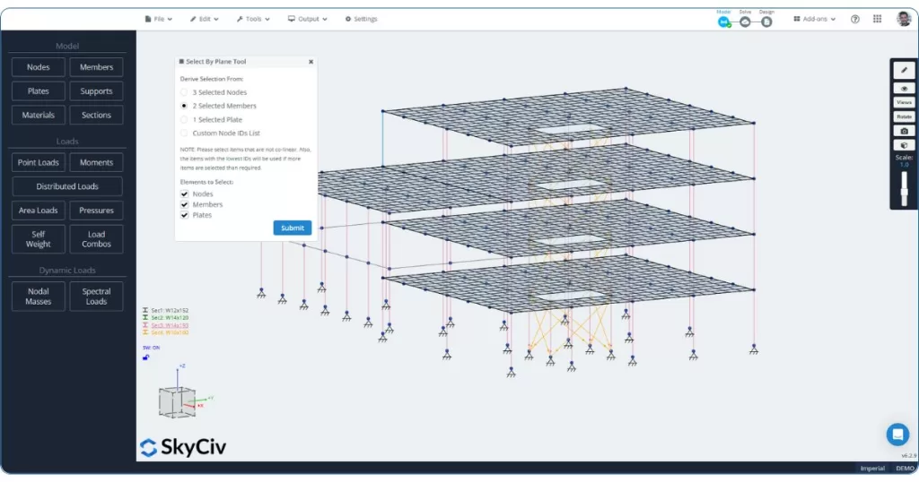
Yeni “Uçağa Göre Seç” Yapısal 3D'deki özellik
Yapısal 3D'miz artık güçlü ve yeni bir araç içeriyor: 'Uçağa Göre Seç'’ fonksiyon. Sağ tıklama menüsünden ulaşılabilir, bu özellik tanımlamanıza olanak tanır geçerli seçime dayalı olarak bir düzlem tanımlamanıza olanak tanır (3 düğümler, 2 üyeler, veya 1 tabak) ve o düzlemdeki tüm öğeleri otomatik olarak seç. Ayrıca, düğümlerin listesini manuel olarak belirterek bu işlev için özel bir düzlem de tanımlayabilirsiniz..
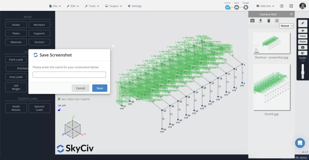
Yapısal 3B'deki ekran görüntüleri için klavye kısayolu
Yeni klavye kısayolumuzla Yapısal 3D'de ekran görüntüsü almak artık daha hızlı. Basitçe kullanın (Ctrl + 9) mevcut görünümünüzün ekran görüntüsünü almak için. Bu küçük ama kullanışlı eklenti, çalışmanızı hızlı bir şekilde belgelemenize ve ekip üyeleriyle paylaşmanıza yardımcı olacaktır..
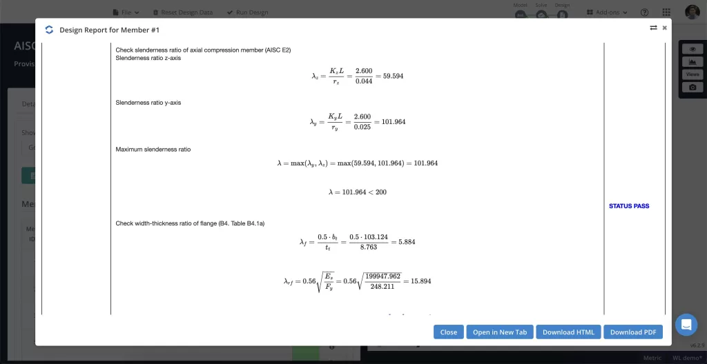
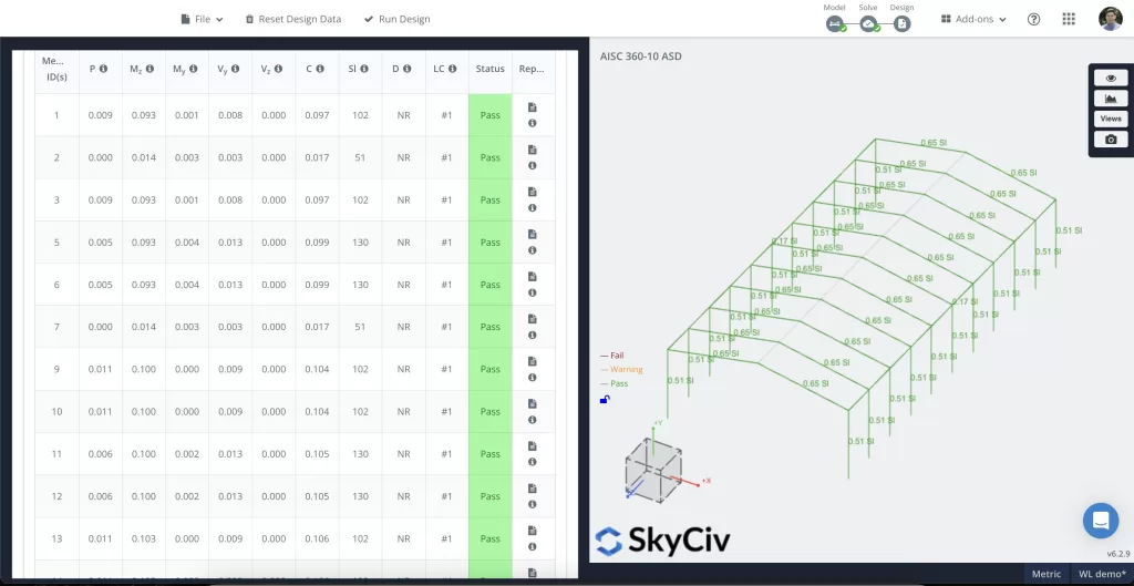
Geliştirilmiş AISC 360 çelik eleman tasarım hesaplamaları
Bağımsız bir inceleme ve doğrulamanın ardından, AISC için hesaplamaları ve raporları geliştirdik 360-16 ve 360-10 standartlar. Bu güncellemeler tasarımlarınızın en yeni kodlarla uyumlu olmasını ve daha da iyi hassasiyet sunmasını sağlar. Bu güncellemeler hakkında daha fazla bilgi için, lütfen tüm değişiklik günlüğümüze göz atın.
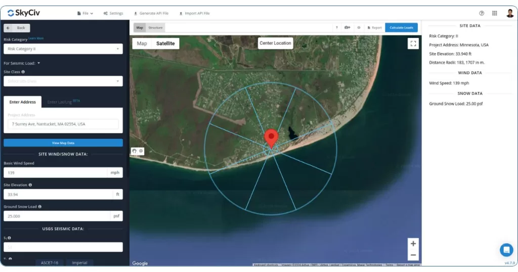
Yeni “Uzaklık Yarıçaplarını Çiz” Yük Oluşturucudaki araç
Yakın zamanda yeni bir tane ekledik “Uzaklık Yarıçaplarını Çiz” SkyCiv Yük Oluşturucuya giden düğme. Bu özellik, belirli bir yarıçapa sahip bir daire çizmenizi sağlar (Üst ve alt çatının boşluğunu ve farkını gösteren yükseklik görünümü) konumdan. Bu özellikle Arazi ve Maruz Kalma Kategorilerinin belirlenmesinde faydalıdır..
Diğer güncellemeler
Yapısal 3D:
🔹Tüm veri sayfalarının üzerindeki düğmeler iyileştirildi ve yinelenen satırları kaldırma seçeneği eklendi.
Üye Tasarımı:
🔹Avustralya'da kullanım için Güney Afrika Çeliği ve Soğuk Şekillendirilmiş çelik şekilleri destekleyin, Avrupa ve Amerika tasarım kodları.
Yük Üreteci :
🔹Saçak yüksekliği için giriş parametresi eklendi (bina yüksekliği) ve NBCC için Maruz Kalma Faktörü ara değerinin hesaplanmasında Engebeli Arazinin Rüzgârın Arka Boyutuna yönelik isteğe bağlı giriş parametresi 2015/2020 Rüzgar Yükü Hesaplamaları.
🔹Kullanıcı arayüzü raporuna yazı tipi boyutunu ve rengini düzenlemek için yeni rapor ayarları eklendi. Buna Ayarlar düğmesini kullanarak erişin.
🔹Fransa'nın arıtılması (NF TR 1991) ve Almanya (DIN EN 1991) rüzgar ve kar haritası verileri.
Görmek SkyCiv Değişiklik Günlükleri daha fazlası için ve aşağıdaki özelliklere oy verin SkyCiv Olumlu Oylaması.